
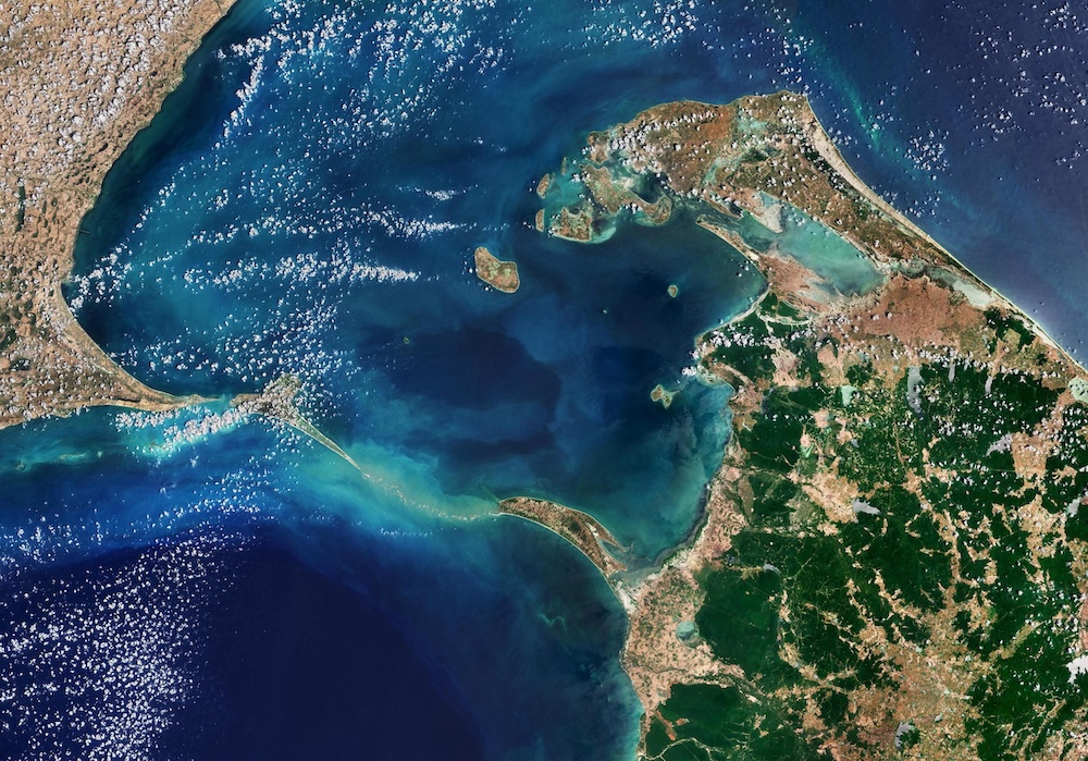
One of the world's most controversial geological formations is a 48-kilometer chain of limestone shoals, coral reefs, and sandbanks that stretches like a ghostly finger across the shallow waters between India and Sri Lanka. Scientists, historians, and believers have been fascinated by it for thousands of years. Hindus call this underwater structure Rama Setu, while Muslims call it Adam's Bridge. It is more than just a geographical feature; it is a bridge between faith and science, mythology and geology, ancient knowledge and modern technology.
Is it a geological wonder or a divine building?
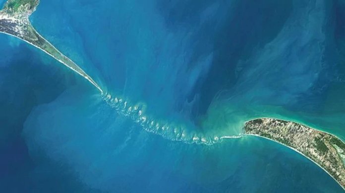
The formation connects Pamban Island in Tamil Nadu, India, near Rameswaram, to Mannar Island off the northwestern coast of Sri Lanka. This makes a natural barrier that keeps the Gulf of Mannar and the Palk Strait apart. The structure is especially interesting because of how it was built and the shallow waters around it, which are usually only 1 to 3 meters deep. This makes it hard for bigger ships to get around Sri Lanka.
The Indian Space Research Organisation (ISRO) and NASA have done some groundbreaking research together that has changed how we think about this strange formation. Scientists made the first complete underwater map of the whole structure using advanced ICESat-2 satellite technology and laser photons that can go through water. They got these data over six years (2018–2023). This revolutionary bathymetric model with a resolution of 10 meters shows that about 99.98% of Ram Setu is still underwater. The ridge rises 8 meters above the seabed and is 100 meters wide.
The mapping project found 11 narrow channels, each 2 to 3 meters deep, that let water flow between the Gulf of Mannar and the Palk Strait. These channels are very important for keeping the structure safe from waves because the bridge is always facing high-energy waves from both sides. The results indicate an advanced comprehension of marine engineering principles, regardless of their natural or artificial origin.
The Ramayana Blueprint: Ancient Engineering Plans
The Hindu epic Ramayana gives very detailed accounts of how the bridge was built, including engineering methods that are still used in civil engineering today. Valmiki's story says that Prince Rama had to move his huge army across dangerous waters to save his wife Sita from the demon king Ravana in Lanka.
The epic talks about a methodical way to build bridges that includes surveying the site, making plans, designing, and building. Varuna, the god of the ocean, suggested Nala, the son of Vishwakarma, the god of architecture, as the project's chief engineer. The Vanara army used building methods that are similar to modern engineering principles, thanks to Nala's expert guidance.
The Ramayana says that the Vanaras first drove trees into the ocean floor to make pile foundations. Then, they put rocks and boulders on top of this foundation to make a path. The text talks about workers using measuring poles and strings to keep the bridge straight. These are very similar to how people build things today, when they use measuring tape and line alignment. Some Vanaras moved big rocks that were said to look like mountains, while others formed production lines to make sure that construction was done in an orderly way.
The original Sanskrit text makes a big deal out of the fact that the bridge was built with trees and rocks that were cut by machines. This goes against the common belief that Rama's name was on floating stones. Valmiki tells how big rocks were quarried and put in the sea in a planned way, where they sank to make a base for a wooden superstructure. It is said that the whole construction project took five days and was 100 leagues long.
The Badrinarayanan Investigation: A Scientific Controversy
Dr. S. Badrinarayanan, who used to be the head of India's Geological Survey, was the most important person to challenge the natural formation theory. His thorough investigation included drilling 10 bore holes along the bridge's alignment, which showed geological features that couldn't be explained in a normal way.
Badrinarayanan's team found a layer of calcareous sandstone, corals, and boulder-like materials that was about 6 meters below the surface. The most surprising thing they found was loose sand layers 4 to 5 meters deeper, with hard rock formations below them. Researchers were confused by this geological arrangement because corals usually grow on solid rock instead of loose sand.
Underwater diving teams looked at the structure up close and found that the boulders were not typical marine formations. Instead, they looked like they came from one of the causeway's shores. In these areas, there was evidence of ancient quarrying activities, which suggests that people were deliberately extracting and placing materials. Dr. Badrinarayanan determined that materials from both shores were methodically deposited on the sandy ocean floor to construct the causeway.
The geological evidence shows that the building was done in a planned way: "The shape of the boulders and the type of material clearly show that this is a man-made structure. We saw similar rocks on Rameswaram and on the Sri Lankan side, which shows that the materials came from both sides." Nevertheless, these findings are still debated by the scientific community at large, which mostly agrees that the formation was caused by natural geological processes.
Temporal Mysteries: Dating the Unknowable
One of the most controversial things about Ram Setu is figuring out how old it is, which has big effects on people who believe it came from mythology. Radiocarbon dating of diverse samples has yielded contradictory outcomes, resulting in what researchers refer to as "epistemic plurality"—the coexistence of multiple valid interpretations.
Some studies say that the coral formations on the bridge are between 500 and 600 years old, while others say that some parts are 125,000 years old. A major study of core samples taken from 260 meters below the surface found microfossils that suggest the structure was built at least 18,400 years ago. But these dates show when corals grew on the structure that was already there, not when the formation that was underneath it started.
The age estimates of 7,000 to 10,000 years for some parts make interesting links to Hindu history. This time period fits perfectly with the Treta Yuga, which is the period in Hindu cosmology when Rama lived. Some researchers assert evidence for an antiquity of 1.7 million years; however, these claims lack mainstream scientific validation.
Historical records offer supplementary temporal indicators. Temple inscriptions at Rameswaram show that the bridge was still walkable until 1480 CE, when a strong cyclone destroyed a lot of it and made the channel deeper. This implies that a more significant structure existed in comparatively recent historical periods, corroborating theories of human augmentation of natural foundations.
The Vanara Enigma: Real Beings or Mythical Creatures?
The identity of the Vanara, the "ape-like beings" said to have built the bridge, is probably the most interesting part of the Rama Setu mystery. Conventional interpretations regard them as mythical entities; however, contemporary anthropological studies indicate a more intricate reality.
The Sanskrit word "Vanara" literally means "forest dwellers," not "monkeys." It refers to beings who wore clothes, lived in organized groups, and knew a lot about engineering. The Ramayana says that they were divine beings made to help Rama and that they were both smart and very strong physically.
It is interesting that the time period that is usually linked to the Treta Yuga (2.5 million to 869,000 years ago) lines up with major changes in human evolution. The genus Homo appeared about 2.5 million years ago, and Homo habilis was the first primate to use tools in a planned way. Homo erectus and Homo ergaster had evolved by 1.8 million years ago. Evidence suggests they lived in groups, made temporary homes, wore clothes, and made advanced stone tools.
These early humans exhibited the initial indications of structured civilization within primates, precisely the traits ascribed to the Vanaras in ancient literature. Could the epic's use of the term "ape-men" really be a reference to early human ancestors who had the engineering skills to build such a huge structure? This reading would change the Ramayana from a work of pure fiction to a record of real events that happened long ago.
The Sethusamudram Controversy: Modern Politics Meets Ancient Heritage
The Sethusamudram Shipping Canal Project, which would make the Palk Strait navigable for ships, is the biggest threat to Ram Setu's preservation right now. The project was first thought of in 1860. Its goal is to let ships go directly between India's eastern and western coasts without going around Sri Lanka, which could save 10 to 30 hours of travel time.
In 2005, the Indian government approved the $300 million project, which was later changed to almost $3 billion. The plan was to dig a 44.9-nautical-mile deepwater channel. But the proposal faced a lot of opposition from many groups. Environmental groups said that it would destroy the ecosystem in the Gulf of Mannar Marine National Park, which is home to 3,600 species and 50,000 fishing families. Economic experts were unsure if the project would work, saying that ships would lose money using the canal because the time savings weren't enough to make up for the tariffs.
Most importantly, Hindu groups and political parties strongly opposed the proposal, seeing it as an attack on sacred heritage. People all over India protested, saying that the project was an attack on Hindu culture. After legal challenges, the Supreme Court of India put a stop to all dredging operations in September 2007.
The government's 2018 affidavit to the Supreme Court effectively ended the debate by promising to look into other ways that would not harm Ram Setu. The project is still on hold for an unknown amount of time, which shows how hard it is to balance economic growth, protecting the environment, and preserving religious heritage in modern India.
Geological Processes: The Natural Formation Theory
Natural formation theories based on well-documented processes are supported by mainstream geological surveys. During the Last Glacial Period (115,000 to 11,700 years ago), sea levels dropped 120 meters below where they are now, making the shallow Palk Strait completely dry land. This made a land bridge between India and Sri Lanka that stayed open until the Holocene seas rose and covered it about 7,000 years ago.
About 5,000 years ago, the visible shoals came back as the sea levels in the area dropped again. Geological surveys find that there are many ways that formations happen, such as continuous sand deposition from the Kaveri River, longshore currents creating barrier islands, coral growth on sand deposits forming limestone shoals, and tectonic movements like crustal downwarping and block faulting.
The structure is made up of parallel ledges of sandstone and conglomerates. The surface is hard, but it gets softer as you go deeper, turning into sandy banks. The Marine and Water Resources Group of ISRO says that Adam's Bridge is made up of 103 small patch reefs. These natural processes can explain how the formation happened without any help from people.
NASA's Clarification and Satellite Evidence
NASA had to make an official statement after people said that satellite images from the agency "proved" that something was built by people. NASA was very clear when it said, "The images reproduced on the websites may well be ours, but their interpretation is certainly not ours. Remote sensing images or photographs from orbit cannot provide direct information about the origin or age of a chain of islands, and certainly cannot determine whether humans were involved in producing any of the patterns seen".
This clarification points out an important limitation: even though satellite technology can show physical features with amazing accuracy, it can't say for sure whether structures are natural or man-made. These determinations necessitate comprehensive field studies, sampling, and geological analysis—methodologies that have consistently endorsed natural formation hypotheses within mainstream research.
Current Research and Future Directions
The 2024 ISRO-NASA joint mapping is the most advanced scientific study of Ram Setu so far. Using ICESat-2's water-penetrating laser technology, researchers gathered about 200,000 photons that showed the depths of the seafloor across the whole formation. The bathymetric model with a 10-meter resolution gives us more information about the structure's underwater topography than ever before.
Future research directions encompass extensive core sampling to elucidate geological history, sophisticated dating methodologies to reconcile age discrepancies, thorough environmental impact assessments, and archaeological surveys of adjacent areas to uncover evidence of ancient human activity. The ongoing scientific investigation continues to enhance our comprehension while honoring the structure's cultural importance.
Conclusion: A Bridge Between Two Worlds
Rama Setu goes beyond being just a myth or a geological formation; it stands for humanity's never-ending search for meaning and understanding of where we come from. The structure makes us think about how different kinds of knowledge can live together and help each other, whether we look at it from a scientific, religious, or historical point of view.
The question of whether Ram Setu is natural or man-made may not be as important as understanding what it means: our interest in ancient mysteries, the power of collective memory, and the deep human need to connect with our past. As technology gets better and better, it keeps finding new things about this strange formation. Rama Setu is still what it has always been: a bridge that connects not only two landmasses, but also different ways of thinking about our world and our place in it.
Ram Setu is a testament to the lasting power of human curiosity and the mystery of our ancient heritage. It was built by divine Vanaras, early human ancestors, or shaped entirely by geological forces over thousands of years.